An Overview of Fissures in the East Valley of the Phoenix Metropolitan Area
The map below is a hydrogeologic map, published in 2017, of the Superstition Vistas Planning Area. The city of Apache Junction is the urban area in the NW corner of the map. Route 60 is oriented W-E in that corner, but then becomes oriented NW-SE in the center portions, and becomes W-E again at Florence Junction near the SE corner of the map. The more darkly colored rock units near the right edge are exposures of bedrock, whereas the majority of the map is colored light blue to indicate alluvium that is derived from the weathering of the bedrock and the transportation of this rock debris to the downslope areas that form the central and western parts of the mapped region. The map base predates the modern development of the majority of Gold Canyon in the era of 2000-2002, but the older homes in Gold Canyon are located primarily on or near Kings Ranch Road and are displayed as the tight cluster of labeled black dots (indicating water wells) near the top center of the map.
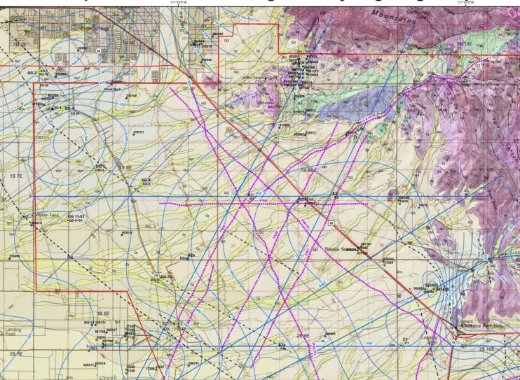
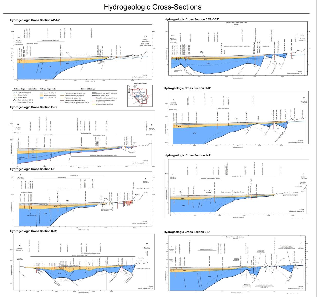
Within the light blue colored alluvial area, the above map uses thin blue contour lines to indicate depth (in feet) below land surface to groundwater. The thick blue straight diagonal (SW-NE) lines are cross-sections that show the subsurface geology. These cross-sections appear in the images below.
The northern-most cross-section line on the above image is labeled I-I on the map and extends into the early-developed areas of Gold Canyon along the NE end. This cross-section is shown in more detail on the image below. The many red vertical lines near the NE end are individual water wells that serve the homes which are located on or near Kings Ranch Road.
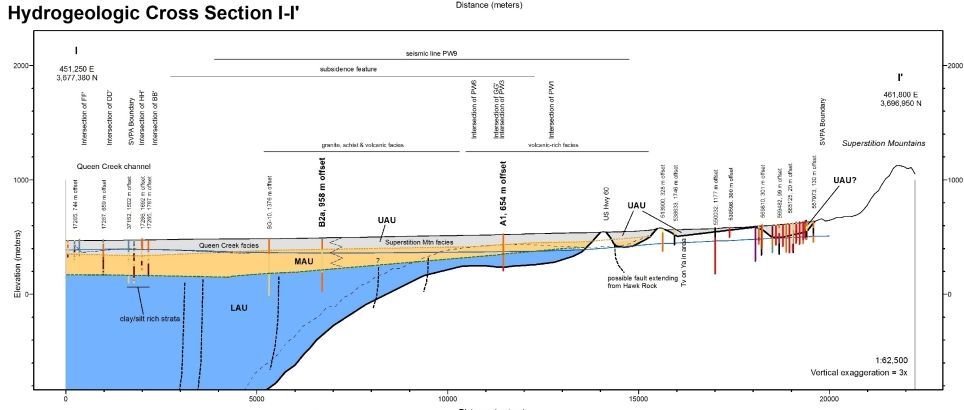
On the above cross-section, notice the shallow depth of alluvium to a slightly inclined erosional bedrock surface that deepens toward the west. This slightly inclined erosional surface is called a pediment. Pediments are formed in a desert area due to a rising base level (the lowest level to which streams can erode), which is caused by a gradual filling of the local basin into which the local streams are flowing.
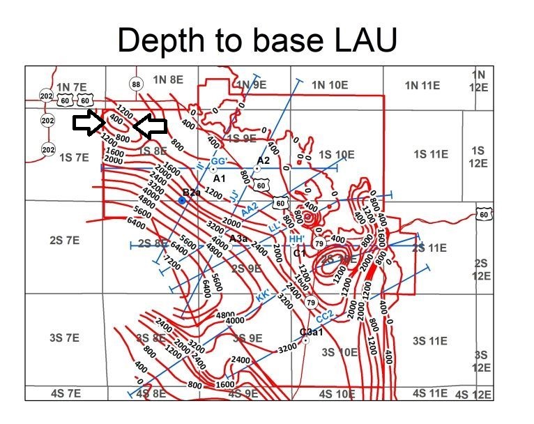
The image below shows the depth to the base of the Lower Alluvial Unit (LAU) with red contour lines, which is the same as the depth of the top of the bedrock surface beneath the alluvial valley fill. The concentric ellipses between the two black arrows in the NW corner of the mapped area (labeled 1200, 800, 400) indicate the location of an inselberg which has (or had) the name "Hawk Rock." Unfortunately, all of the above-ground portion of this inselberg was removed with recent industrial development.
The image below shows Hawk Rock as it existed before it was mined away by the property owner. This historic image was published in the Field Trip Guidebook for the Final Meeting of the UNESCO-IGCP641 Project, "Land Subsidence and Earth Fissuring in Arizona and the Southwest, 6 November 2019, Tempe, Arizona."
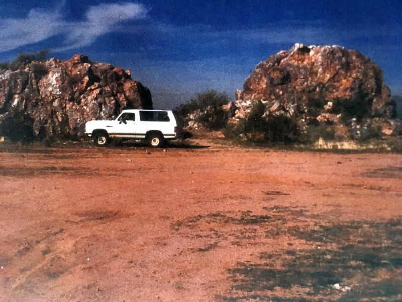
The inselberg in the above image is composed of quartzite. Its composition and structure is described in Open-File Report 96-8 (see references at the end of this webpage) which is reproduced in Appendix 1.
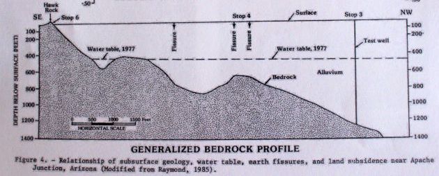
The cross-section view below shows the Hawk Rock inselberg as the tip of a bedrock mountain block that has been buried in a former depression that has been filled with alluvium.
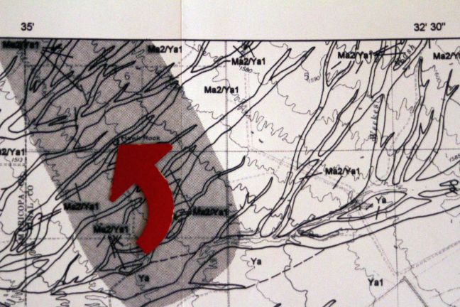
The image below shows an arrow pointing to the location of Hawk Rock on a topographic map that predates the removal of Hawk Rock. The shaded area that surrounds Hawk Rock on this map is the area that is subject to the development of ground fissures.
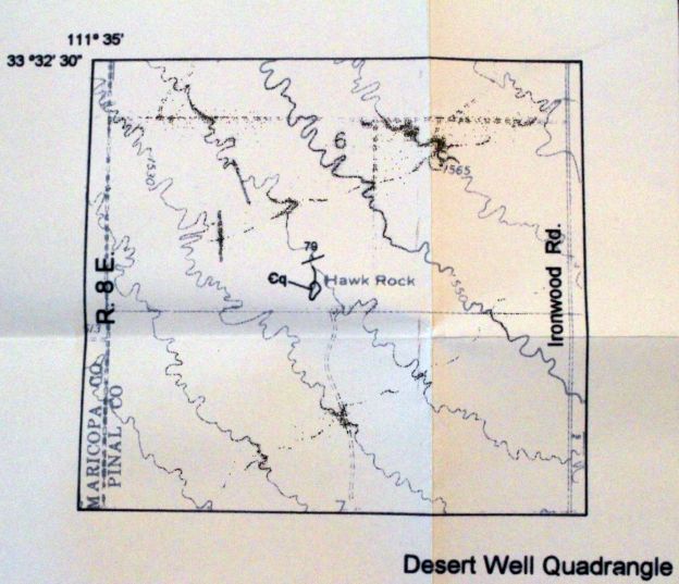
The image below shows a more detailed view of the former Hawk Rock inselberg feature, as portrayed on a topographic map.
The Dictionary of Geology & Mineralogy, second edition, defines inselberg as the following: "A large steep-sided residual hill, knob, or mountain, generally rocky and bare, rising abruptly from an extensive, nearly level lowland erosion surface in arid or semiarid regions. Also known as an island mountain."
The image below shows the area that has subsided with the progressive withdrawal of groundwater from the alluvium of the valley fill. Because it is centered on the location of the former Hawk Mountain, it is referenced as the Hawk Mountain area.
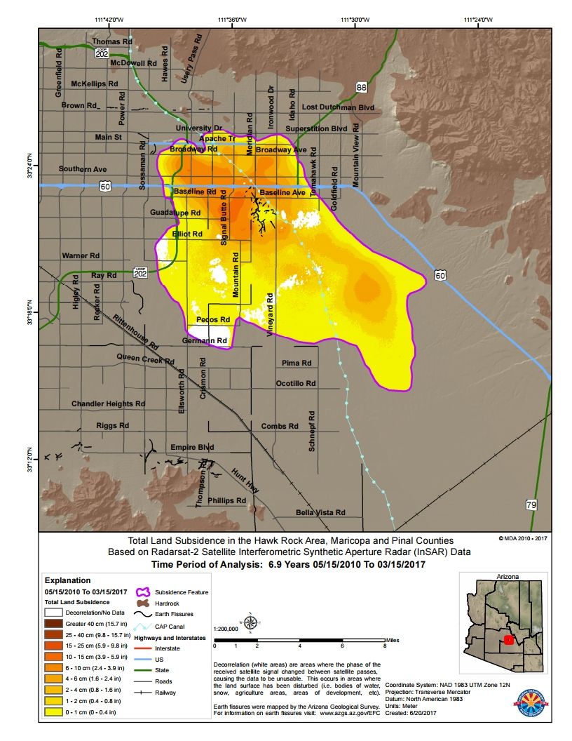
The withdrawal of ground water causes differential compaction of the alluvium, particularly where the thickness of the alluvium varies over short horizontal distances, as it does near the former Hawk Rock. On the image above, notice the concentration of the dark lines on the map, which indicate the locations of known ground fissures. They are concentrated near the Hawk Mountain location.
The image below is shows this fissured area in more detail. The location of the former Hawk Rock is now occupied by the industrial area in the center of the image.
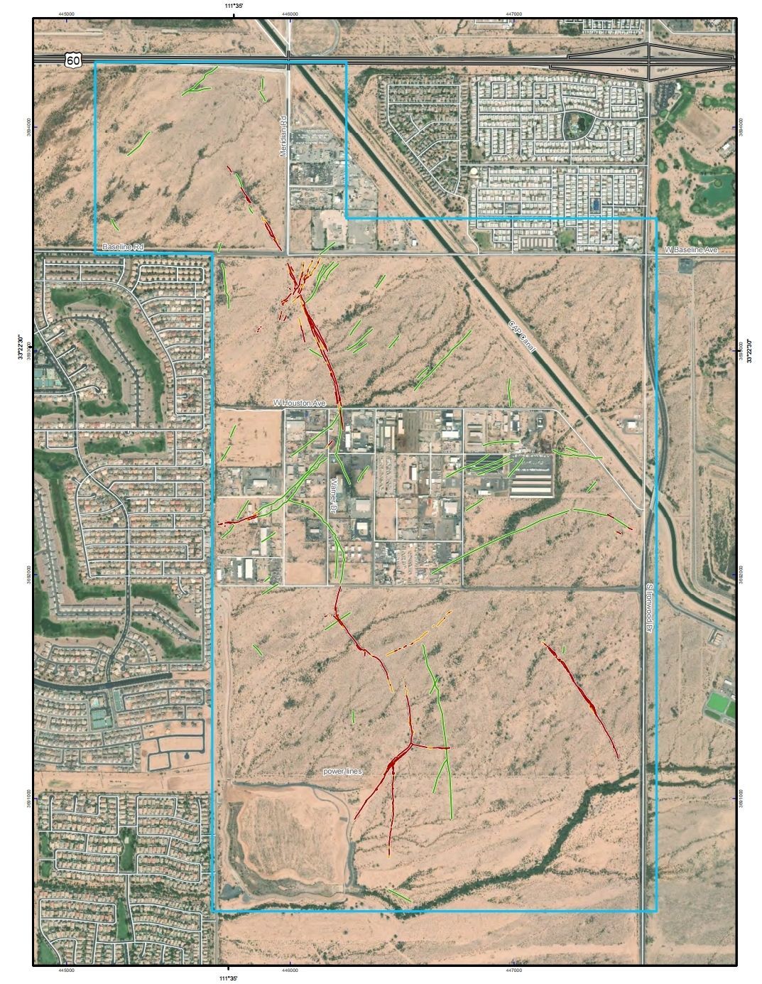
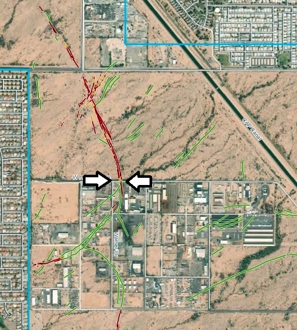
The image below shows a closer view of the industrial area, with arrows indicating where Houston Avenue (the street that runs W-E) has been negatively affected by the development and expansion of the N-S trending ground fissure.
In the image above, notice that fissures have developed very near the recently-built housing development that is apparent along the western edge of the area shown.
Appendix 1. Description of Hawk Rock quartzite.
The Hawk Rock inselberg is composed of quartzite. It is described in Open-File Report 96-8 as follows: "Quartzite (Cambrian?) -- Strongly indurated light gray quartz arenite. The only outcrop is Hawk Rock in the Desert Well Quadrangle, south of Apache Junction just west of Ironwood Road. The exposure is fractured and slightly varnished. Bedding is steeply inclined. Medium-scale cross-beds are visible, showing that the top is to the northwest. May be correlative to the Cambrian Bolsa Quartzite. The unit was not correlated with the Proterozoic Dripping Spring Quartzite because the nearest outcrops of the Dripping Spring Quartzite exposed between Peralta Canyon and Florence Junction are finer-grained and contain mostly quartz arenites and argillites. However, this does not exclude the possibility that the quartzite at Hawk Rock is Dripping Spring Quartzite."
References
Field Trip Guidebook for the Final Meeting of the UNESCO-IGCP641 Project, "Land Subsidence and Earth Fissuring in Arizona and the Southwest," 6 November 2019, Tempe, Arizona.
http://www.azaeg.org/wp-content/uploads/2019/09/IGCP-Workshop-Program-1.pdf
Pewe, T. L., Raymond, R. H., and Schumann, H. H., Land Subsidence and Earth-Fissure Formation in Eastern Phoenix Metropolitan Area, Arizona, in Davis, G. H. and VandenDolder, E. M., eds., Geologic diversity of Arizona and its margins: Excursions to choice areas; Field Trip Guide Book, 100th Annual Meeting, The Geological Society of America, Phoenix, Arizona, October 26 - 29, 1987: Arizona Bureau of Geology and Mineral Technology Special Paper 5, p. 199-204. Special Paper 5
Skotnicki, S. J. and Ferguson, C. A., 1997, Bedrock Geologic Map of the Apache Junction and Buckhorn Quadrangles, Maricopa and Pinal Counties, Arizona: Arizona Geological Survey Open File Report 96-8, 17 p, 2 sheets.
Report 96-8