Lehigh Valley Geology Field Trips
The subdued topography of the Lehigh Valley belies the enormous thickness of sediments beneath the ground surface, the complicated structures within and between the buried rock units, the span of geologic time involved in forming the rocks and their structures, and the erosional and glacial processes that produced the major topographic features of the familiar landscape. The area has igneous, sedimentary and metamorphic rocks and gives easy access to both glaciated and non-glaciated terrains. It has rocks formed by sedimentation in both continental and marine environments. It has everything but a currently active volcano and a contemporary shoreline. It is, indeed, an interesting location to study geology.
Three Introductory Geology field trips are usually run each time the course is offered.
Field Trip #1 investigates the rocks and structures within the area to the south of the Moravian campus and involves seeing both the oldest and the youngest rocks in the region. The oldest have been severely deformed and the youngest are relatively unchanged, so the deformations occurred during the time interval between them.
Field Trip #2 investigates the rocks and structures to the north of campus. The rocks exposed in this region have ages intermediate to those seen on the first trip. The timing of the deformations within the Appalachians and the nature of these deformations are revealed and refined by the rock structures in evidence.
Field Trip #3 emphasizes the morphology and materials that resulted from the recent glaciation of the area to the north of campus, including the Pocono Mountains. The retreat of the last glacier occurred a mere 17 thousand years ago, which is a "blink of the geologic eye." Pre-glacial deformational structures within the bedrock are also examined, and their significance is related to those seen on the other two fields.
(Click on any image to enlarge)
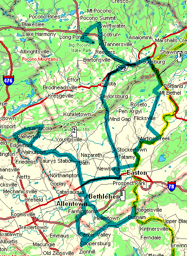
(Source: DeLorme 3-D TopoQuads)
The field trip routes are indicated on the above topographic map in the
blue/green shading.
Field Trip #1 is to the
south.
Field Trip #2 is to the
northwest.
Field Trip #3 (the
glacial trip) is the longest and is to the northeast.
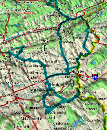
(Source: DeLorme 3-D TopoQuads)
The topography of the local region and the routes of the three field trips are indicated on the above map. The Lehigh Valley is topographically low because it was developed on limestone and dolomite, both of which are soluble under humid climatic conditions. Other rocks are more resistant and form the hills and mountains.

(Source: PA Geological Survey)
The above map shows the age of the rocks for the entire state of Pennsylvania. The color code along the bottom shows the rock ages, with the oldest on the right and the youngest on the left.
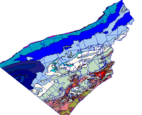
(Source: ArcView GIS Software)
The geology of the Lehigh/Northampton county region is indicated on the map above. The rock ages, arranged from oldest on the bottom to youngest on the top, are as follows:
start age end age
Pleistocene (2 million to 17 thousand years) - not shown on the above map
Triassic
(245 to 206 million years) - greens
Silurian (438 to 408 million years) - purples
Ordovician (505 to 438 million years) - blues
Cambrian (570 to 505 million years)
- grays
Precambrian (older than 570 million years)
- reds and oranges
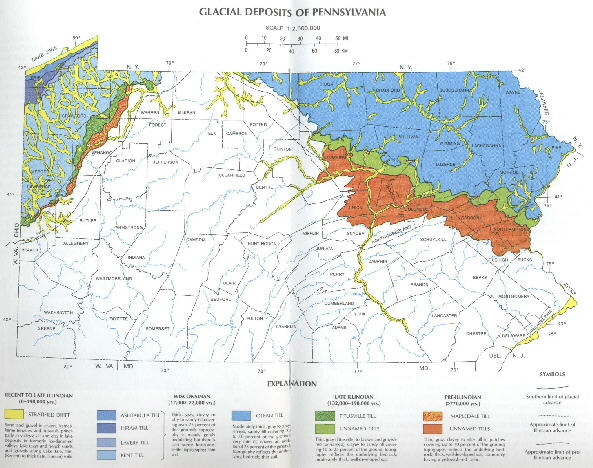
(Source: PA Geological Survey)
North America was glaciated during the Pleistocene Epoch, which started about 2 million years ago and ended with the melting of the last ice sheet. During the Pleistocene, there were about 20 separate glacial and interglacial episodes, some more extensive than others, at intervals of about 100 thousand years. During the more extensive glaciations, the ice sheet formed over Canada and advanced south to cover all of New England and both the northeastern and northwestern portions of Pennsylvania. Where younger glacial advances overrode the deposits left from previous ones, the earlier evidences were destroyed. The Pennsylvania map above shows deposits left from two older glaciations: the browns (about 770 thousand years ago) and greens (about 150 thousand years ago). The blue on the map shows deposits formed by the most recent glaciation. This ice from this glaciation melted off sections of Northampton County only 17,000 years ago. The third field trip examines the evidence from only this most recent glaciation.
The logistics of the Moravian College geology field trips involve the following:
we depart Collier Hall of Science at 12:45 pm
we always have one short stop for refreshments and bathroom
needs about half way in the trip
we usually don't postpone the trip unless the weather
is severe
trips are scheduled when vegetation interferes least with viewing the outcrops
after the leaves have fallen from the
trees, if in the autumn
before the end of leaf bud stage, if in the spring
we return to campus between 5:00 and 5:45 pm, depending
on traffic and the weather
participants should wear attire appropriate for field
conditions and the prevailing weather
we never enter private property without permission
we always act with safety in mind for ourselves and for
others
we respect the rights of the property owners and all
others
we remain aware of traffic which may be close-by at
some sites
we stay away from active quarry operations