Lehigh Valley Geology Field Trips
Field Trip 2, Stop 2
Keystone Cement Company, Bath Quarry:
Cement Limestone And Its Deformation
Caution: access to this property is
restricted.
Permission is needed to enter the property and requires signing a "Release
of Liability" form and checking in at the quarry office just prior to
entering the site.
(Click on images to enlarge)
(Source: DeLorme 3-D TopoQuads)
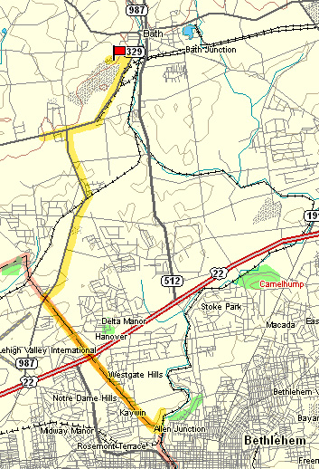
The Keystone quarry site is along PA Route 987, but a half-mile excursion west along PA Route 329 takes you to an abandoned lime kiln adjacent to the parking lot of a bank.
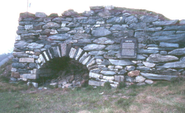
The lime kiln, now designated with a historic marker, had been used by a farmer for heating the local Jacksonburg Limestone (CaCO3) to produce lime (CaO). Farmers in this area spread lime on the soil of their fields to replace the calcium that is removed by solution. The lime application improves the productivity of the soil.
Proceed east on PA Route 987 to the Keystone Portland Cement company, about a mile south of Bath. Permission for entering any part of the Keystone property must be obtained at the plant office. Stop #2 is in an inactive portion of the quarry complex on this property. The floor of this portion of the quarry has been flooded by groundwater since the quarry operations here became inactive. We go about half way down the road leading to the quarry bottom. DO NOT THROW ANYTHING INTO THE QUARRY! DO NOT GO TOO NEAR TO THE EDGE OF THE QUARRY!
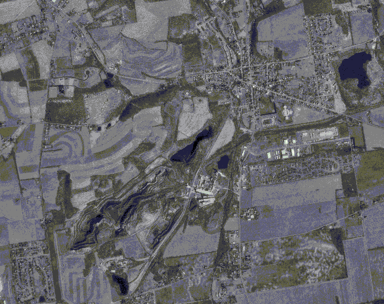
(Source: ArcView GIS software)
The aerial photograph above shows the small community of Bath at the upper right of center. The quarry is in the center of the photograph, directly north of the major highway, PA Route 987. The active portion of the quarry extends toward the lower left edge of the photograph. The inactive portion is closer to Bath.
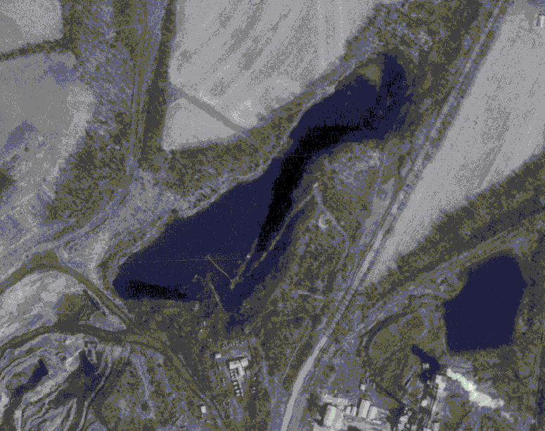
(Source: ArcView GIS software)
The photograph above is a higher magnification view of the previous aerial photograph. The inactive portion of the quarry is partially flooded, which appears black on the photographs. The access road to the bottom is between the highway and the quarry floor. The quarry is elongated and parallels the highway. The long axis of the quarry is oriented along the strike of the bedrock, which is the Jacksonburg Formation of Ordovician age (505 to 438 million years). The Jacksonburg is composed of limestone (CaCO3) that has excellent qualities for making Portland cement, so the cement quarries and cement plants in the Lehigh Valley are aligned along the surface exposures of the Jacksonburg Formation.
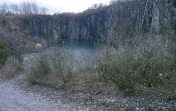
The photograph above shows the quarry as seen from the service road which descends into it. The quarry exposes tilted and foliated beds of limestone. Foliation is oblique to the bedding, creating fragments that have more the appearance of slate than limestone, but a test with dilute hydrochloric acid reveals vigorous effervescence. Tilting and foliation give evidence to the compressive deformation that partially metamorphosed these rocks. Limestone (and marble, the metamorphic equivalent of limestone) is composed of the mineral calcite, which has the chemical formula of CaCO3 and typically appears white in color.
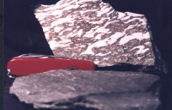
The photograph above shows two pieces of Jacksonburg Limestone from this quarry. The piece in the background shows some recrystallization of the calcite, which produces the white variegations in the otherwise dark gray-to-black limestone. This sample has been partially metamorphosed to a marble. The piece of limestone in the foreground splits into thin sheets along foliation which developed when the rock was metamorphosed, so it appears more like slate than limestone.
Regional geologic features NOT seen on these field trips.
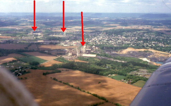
Cement plants occur in the Lehigh Valley where the Jacksonburg Limestone is exposed at the surface. The view above shows an alignment of three cement plants. A large quarry in the Jacksonburg limestone can be seen to the right of the nearest plant. The plants make Portland cement, which is used in making concrete. The Lehigh Valley region supplied all the cement that was used for the building of the Panama Canal. Notice the lack of surface drainage over the limestone bedrock.
(Source: ArcView GIS software)
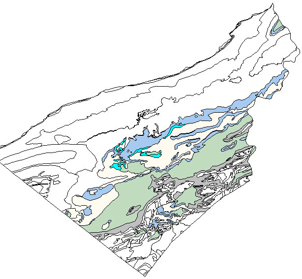
The above map shows the distribution of limestones (CaCO3) and dolomites (CaMg(CO3)2) within the boundaries of Lehigh and Northampton counties. Limestones and dolomites are collectively referenced as "carbonates." On the above map, those carbonates of Cambrian age (570 to 505 million years old) are shown as shades of gray, and those of Ordovician age (505 to 438 million years) are shown as shades of tan and blue. The darker blue is the Jacksonburg Limestone. The cement plants within the Lehigh Valley are all located on the Jacksonburg Limestone because this unit is unusually pure and has ideal qualities to serve as source material for the manufacture of cement. All the limestones and dolomites within the Lehigh Valley produce the lower topographic areas and fertile soils, and all are subject to the development of solution features, including the formation of sinkholes.
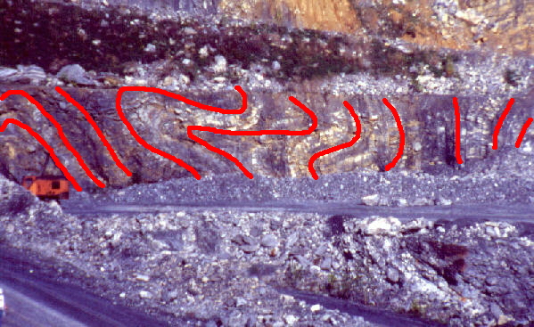
This is an exposure of the Jacksonburg Limestone in the active Whitehall quarry near PA Route 145, north of Allentown. The crane near the left edge gives a sense of scale. The beds have been highly deformed by the compressive forces associated with building the Appalachian Mountains. Red lines have been drawn on the photograph to show the tilting and folding of the beds, which were originally horizontal when they were deposited as an accumulation of limy mud at the bottom of a shallow sea during the Ordovician Period (505 to 438 million years ago).
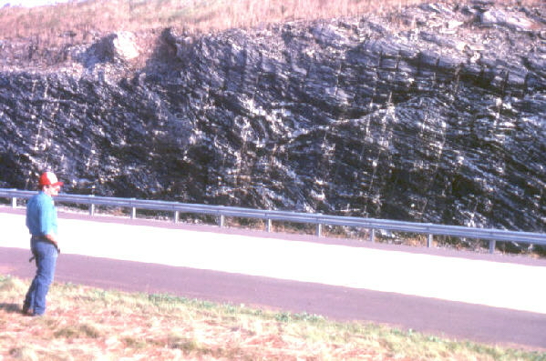
This outcrop of the Jacksonburg Limestone is exposed in a road cut along Interstate 78 near the PA / NJ border. ON OPERATING INTERSTATE HIGHWAYS, PARKING ON THE SHOULDER IS RESTRICTED TO EMERGENCIES ONLY. Note the white variegations of calcite within the dark limestone.
End Stop #2 of Field Trip #2
(all photography by J. Gerencher)