Lehigh Valley Geology Field Trips
Field Trip 3, Stop 4
PPL Martin's Creek Power Plant on Terminal Moraine
(Click on images below to enlarge)
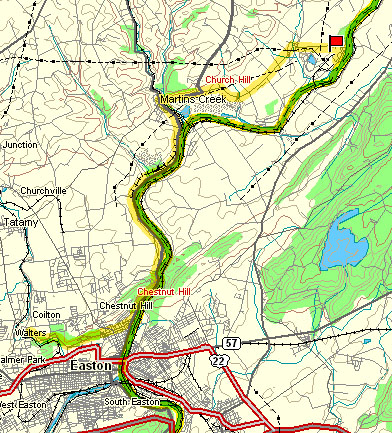
(Source: DeLorme 3-D TopoQuads)
From Bushkill Creek, reverse direction, take Lafayette Street to PA Route 611 which parallels the Delaware River. Go north (upstream) past the town of Martin's Creek until PA Route 611 takes a sharp left. Continue straight on the minor road. The power plant is in the distance. You can't miss seeing it.
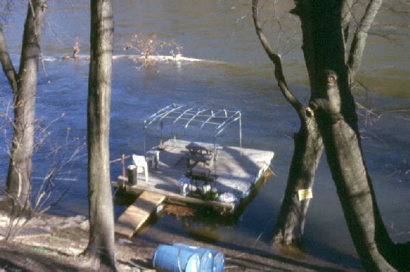
About a mile upstream from where Lafayette Street joins PA Route 611, there is a small bedrock island in the Delaware River. When conditions have been very dry (a probability of only about 1 in 10), you might be able to walk from the bank to the bedrock island. THE ISLAND IS PRIVATELY OWNED AND PERMISSION IS NEEDED TO WALK OUT TO IT. The island is Precambrian gneiss, similar in composition and age to South Mountain, Camel's Hump, and the previous stop. The exposure of gneiss has been smoothed into a roches mouttonnees by the second-last glaciation. Subsequent stream action by the Delaware River potholed the surface of this bedrock island.
The above photograph shows a potholed, glacially polished, bedrock island, a roches moutonnees, at a time of exceptionally low water flow on the Delaware River. The view is looking downstream (south). THE LAND IS POSTED; PERMISSION IS NEEDED TO GO ON THIS FEATURE. For permission, inquire at the nearby gas station/mini-mart.
(Source: PA Geological Survey)
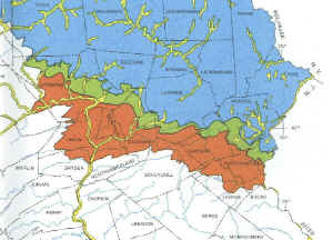
The glacial features in eastern Pennsylvania result from three individual glaciations within the Pleistocene Epoch that were widely spaced in time: the Pre-Illinoian glaciation (rust color - older than 700,000 years), the Late-Illinoian glaciation (green color - 198,000 to 132,000 years ago), and the Wisconsinan glaciation (blue color - 22,000 to 17,000 years ago). The bedrock island in the Delaware River mentioned previously was polished by one of the previous glaciations because it is south of the terminal moraine of the Wisconsinan glaciation, which is shown by the blue on the above map. The oldest glaciation shown (the rust color) covered the city of Bethlehem, including the campuses of Moravian College, and invaded Saucon Valley on the southern side of South Mountain, but did not override the summit of South Mountain.
The Martin's Creek Power Generating Station is built on the Delaware River at the farthest southern extent of the Wisconsinan glaciation.
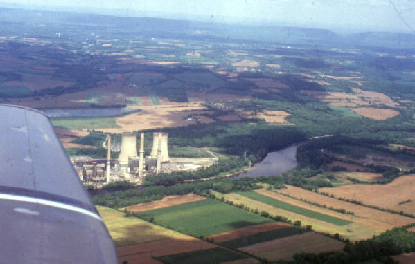
The Martin's Creek Power Plant, operated by Pennsylvania Power and Light Company, is built on the terminal moraine of the last glaciation (the Wisconsinan glaciation). The aerial view is looking northward, with Blue Ridge making the horizon. The notch in the ridge near the right edge of the photograph is the Delaware Water Gap, through which the Delaware River flows toward the power station, which is near the center of the photograph. The Delaware River is in the foreground, so the airplane is over New Jersey looking toward Pennsylvania, and the Delaware River is flowing toward the camera.
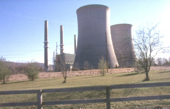
Martin's Creek Power Plant can be seen for miles around. It produces electricity mostly from oil, but also can use coal and, most recently, natural gas. It is NOT a nuclear facility. The thin stacks are for smoke from the fuel combustion, and the broad lower stacks are cooling towers for evaporating water to cool the plant. The water for cooling and operating the plant is obtained from the Delaware River.
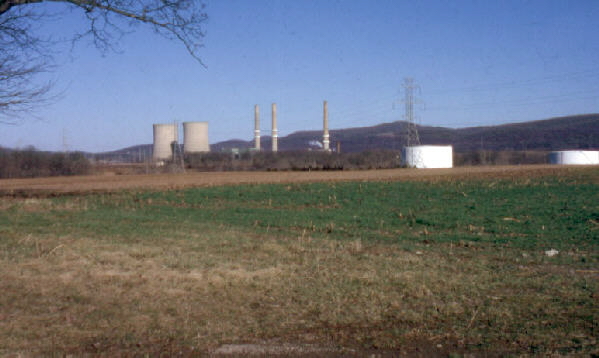
On a clear day the facility can be seen from South Mountain in Bethlehem, which was Stop 1B and 1C of Field Trip #1. The power plant is built on till which marks the terminal moraine of the most recent glaciation. This glacier started its retreat a mere 17,000 years ago. The power plant site has been modified by the power company so the land surface does not have its original post-glacial hummocky appearance, and the till which overlies the bedrock is mostly covered by forest or planted grass in areas of the site which are open to the public.
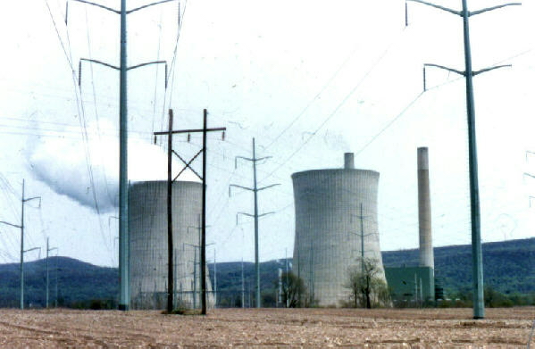
The image above shows smoke from one tall thin stack and steam from the shorter broad cooling tower. Electric lines radiate from the plant to distribution facilities throughout the Lehigh Valley area and beyond.
From this point on field trip #3, the route goes northward and into areas that were under the ice until 17,000 years ago, or less. The topography changes from all points to the south. Glacial erratics are common and appear in stone foundations of buildings and in "stone fences" that separate farm fields. The drainage has been deranged, so natural lakes and swamps are common. The land surface is veneered with till or glacial outwash above the till. Some of these features are evident from a moving car, but others may be only apparent when seen from the air or when viewed on a map.
Related geological features NOT seen on these field trips.

This is a better exposure of till than the till exposures at the Martin's Creek Power Generating Station. Till is unsorted rock debris deposited directly by the ice. It contains a large variety of both grain sizes and rock compositions. Unfortunately, this New Jersey location also collected car bodies that were dumped there, but not by the glacier.
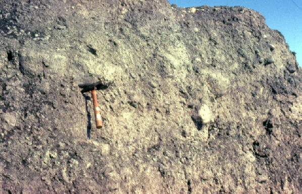
This till is exposed near Wilkes-Barre. Till is composed of unsorted debris deposited directly by the ice. The grain size can vary from mud to boulders, and the composition can include any type of rock that is exposed on the Earth's surface in the area between where the glacier forms and where the till is being deposited. Unusually large boulders deposited by the ice are called glacial erratics. In the photograph, notice the hammer is stuck in the mud, silt, and sand of the exposure, but some pebble-size and cobble-size rocks are evident also. As is evident in the above photograph, tills characteristically show no bedding.
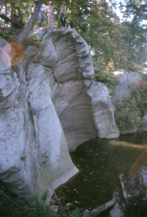
Potholes occur in some portions of the limestone/dolomite bedrock exposed along the Susquehanna River south of Harrisburg. Note the three people above the pothole for scale. The bottom right of the photograph shows the water of the Susquehanna River reflecting the bottom of the undercut outcrop.
(photo by the late Dr. Richmond E. Myers)
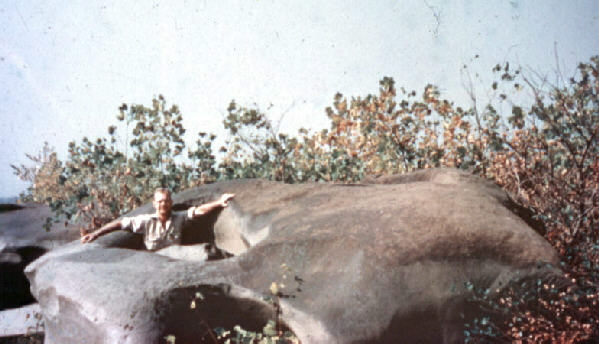
The photograph above shows a pothole in a river bed in New York state. Potholes form where the bedrock is homogeneous and where there are swift water currents, at least occasionally. Most potholes can't be seen because they remain submerged beneath the water surface.
(photo by Steve Seliger)
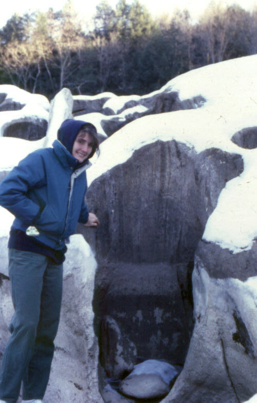
The photograph above shows a pothole in the bed of a Vermont stream. The "tool" for abrading the pothole into the bedrock is evident at the bottom of the pothole.
End Stop #4 of Field Trip #3
(all photographs by J. Gerencher, except for the one by S. Seliger and the one by the late Dr. Richmond Myers)