Lehigh Valley Geology Field Trips
Field Trip 2, Stop 1
Lerch's Quarry: The Allentown Formation
(click on any image to enlarge)
(Source: DeLorme 3-D TopoQuads)
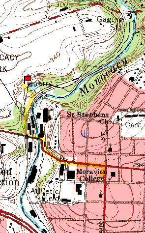
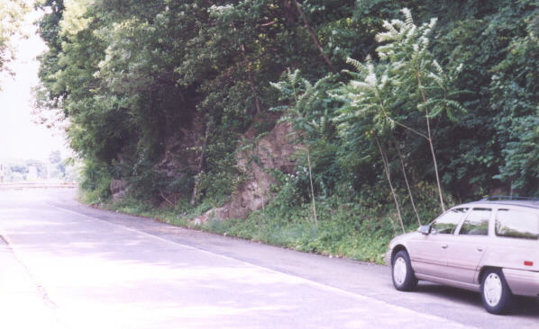
Lerch's quarry is upstream from the bridge on Schoenersville Road (Mauch Chunk Road) that crosses the Monocacy Creek, just off Moravian's main campus. This site is within easy walking distance of the main campus.

(Source: DeLorme 3-D TopoQuads)
The relief map above shows the quarry as an indentation into the bedrock to the left of the floodplain of the Monocacy Creek. The red flag shows the location of the outcrop.

Most of the lowermost floor of the Lehigh Valley is built upon the Allentown Formation, which is composed of limestones and dolomites. The view in the photograph above is from an airplane over Allentown looking east toward Bethlehem.
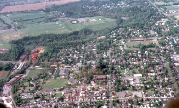
In the photograph above, the Moravian campus is in the foreground and Lerch's quarry is in the wooded area near the left edge. The photograph was taken when a paint pigment manufacturing company was located adjacent to the quarry. The paint pigment operation is visible by the red and yellow deposits formed by the localized air pollution. The site is now occupied by a company that deals with the distribution of insulation materials, so the distinctive red and yellow colors seen in this photograph are no longer conspicuously evident.
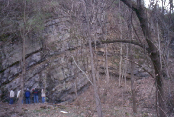
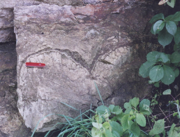
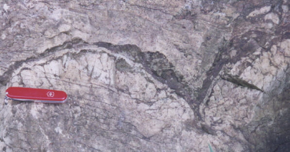
The photograph above shows the rocks in Lerch's quarry. Exposed here are beds of dolomite (CaMg(CO3)2). They were formed as horizontal accumulations of limy mud at the bottom of a shallow sea during the Cambrian Period (570 to 505 million years ago). The structure evident on the face of the quarry is a broad anticline, indicating a subsequent compressive deformation. The dolomite is soluble in rainwater, so this rock tends to be found in the lower topographic portions of the Lehigh Valley, and it tends to be subject to the development of sinkholes on the ground surface above it.
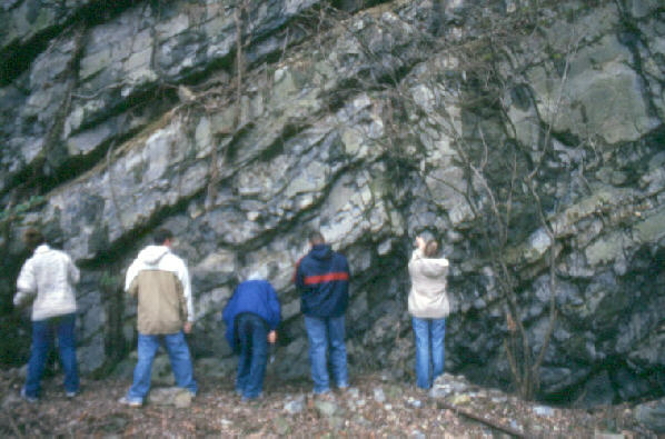
Students in the photograph above examine the Allentown Formation, which is composed of thick beds of dolomite. Some dolomite beds contain oolites and fossil stromatolites, both of which indicate a shallow marine origin for the rocks. The Allentown Formation and the Hardyston Quartzite are both Cambrian in age (570 to 505 million years old), but the dolomite is stratigraphically above the quartzite, so the dolomite is younger than the quartzite. Solution by rainwater causes the development of sinkholes and caves in this rock unit, as seen on field trip #1, stop #6.

The fossil stromatolites in the photograph above are evident as finely laminated "bumps" within the beds and vary in size from less than an inch to several feet across. They were formed by fine sediment being trapped within mats of bacteria and blue-green algae that grew on the ocean floor. Because the algae used photosynthesis, we can infer that the ocean was sufficiently shallow to permit the penetration of adequate sunlight to reach the habitat of the algal mat.
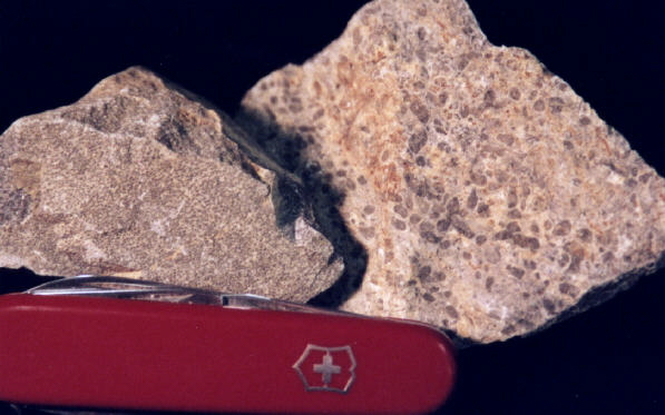
Oolites are small spheres, usually about the size of bird-shot, formed by chemical precipitation from water around grains that are held in suspension by mild wave action. As the grains grow in the water they sink to the bottom. Rocks made from such deposits have an oolitic texture. This texture implies the rock formed from sedimentation in shallow water. The picture above shows two samples of oolitic dolomite taken from Lerch's quarry. The sample on the left is composed of fine spheres, whereas the one on the right is made from coarser ones.
Related regional geologic features NOT seen on these field trips.
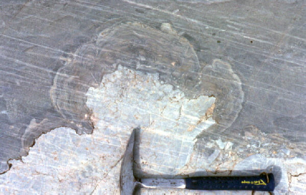
This exposure of the Allentown Formation, which is composed primarily of dolomite (CaMg(CO3)2), occurs in Franklin County in northern New Jersey. Shown here is a fossil stromatolite in cross section. The dolomite bedrock exposed at this outcrop has been polished by the recent glaciation of this portion of the New Jersey. The movement of the ice across this outcrop also caused the glacial striations that are aligned from upper left to lower right of the photograph.
Abundant fossil stromatolites occur in an exposure of the Allentown Formation along the east 13th Street exit ramp of US Route 22 in Easton. Cars and trucks exit the highway at a high rate of speed, so great care must be taken in parking and examining the outcrop. Indeed, we do not stop at the 13th Street exit on any of the field trips.
The picture above shows some of the the fossil stromatolites that occur in the outcrop at the13th Street exit ramp.
The picture above shows a closer view of the the fossil stromatolites at this site. The cusps between the bumps point down in the original sediment, which allows the observer to interpret the beds here as being right-side-up.
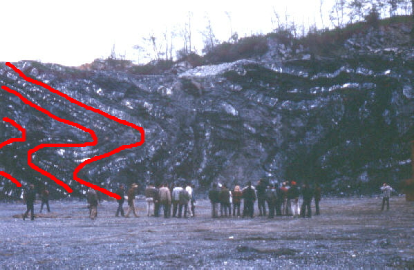
Reems Quarry, outside Elizabethtown (near Lancaster), shows dramatic folding of the limestones/dolomites of the valley floor. Some red lines have been drawn on the image to indicate the folding style. The rocks have been so intensely folded, as a result of the compressive forces associated with the formation of the Appalachian Mountains, that it is difficult to determine the direction of the original top of the beds. Fossil stromatolites (see the previous picture) would allow the resolution of this ambiguity.
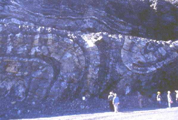
The above picture shows folding within the limestones/dolomites which floor the Lehigh Valley in an active quarry in west Allentown. Before the Appalachian Mountains were formed by compressive forces, these beds were laying horizontally as part of a thick accumulation of similar sedimentary rocks.
Caves develop in the limestones and dolomites of the Lehigh Valley floor. Lost River Caverns in Hellertown and Crystal Cave near Kutztown are located in the soluble rocks of the valley floor. In addition, there are lesser-known caves on the valley floor that have not been commercialized.

(photograph by Tim Smith)
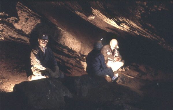
The soluble limestones and dolomites which underlie the floor of the Lehigh Valley contain solution features. This view of two members of the Moravian College Grotto and Outing Club, taken by member R. Tim Smith in the early 1970's, is in Kern's Quarry Cave which is located by the Alpo Plant in Allentown. The stalactites shown here have been vandalized since this photograph was taken.
(photograph by Tim Smith)
Schofer Cave is located about 3 miles northwest of Kutztown University. It occurs on state game lands and consequently is a popular cave for exploration by amateurs. The photograph above, taken in 1990, shows members of the "Scientific Photography" Moravian College January term course in this cave practicing various techniques of cave photography.
End Stop #1 of Field Trip #2
(all photographs by J. Gerencher, except for the two by Tim Smith)