Lehigh Valley Geology Field Trips
Field Trip 2, Stop 5
Devil's Potato Patch in a Wind Gap:
A Geomorphic Extravaganza
(Source: DeLorme 3-D TopoQuads)
(Click on images below to enlarge)
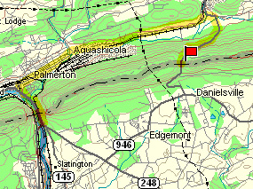
A small road runs north-south across Blue Ridge through Little Gap, past Little Gap Ski Area, and connects the valley to the north to Danielsville to the south.
(Source: DeLorme 3-D TopoQuads)
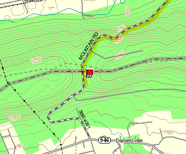
This road reaches its highest elevation within a depression of the ridge -- a wind gap. On the east side of this road is a deposit of boulders, called by the local name, "Devil's Potato Patch."
(Source: DeLorme 3-D TopoQuads)
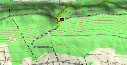
An oblique view shows the wind gap as a local depression in the ridge. Although the gap is called a wind gap, it was carved by a river which has subsequently been captured by the drainage of the Lehigh River. Likewise, if the Lehigh River were to be captured in the future, the present Lehigh Water Gap would then be devoid of a through-flowing river and the gap in the ridge then would be called the "Lehigh Wind Gap." Wind does not carve wind gaps -- water does.
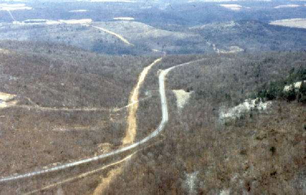
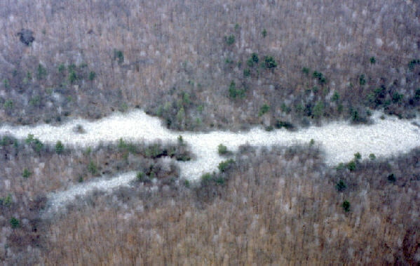
An aerial view, looking from south to north, shows the highway as the bright ribbon, and, to its left, a cleared strip through the forest for a power line. The power line itself cannot be resolved in this picture. To the right of both is an area without trees; this is the boulder field of "Devil's Potato Patch."
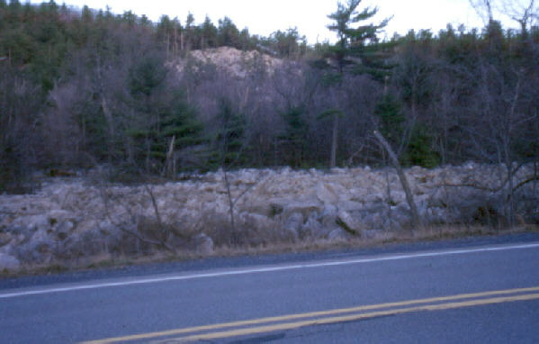
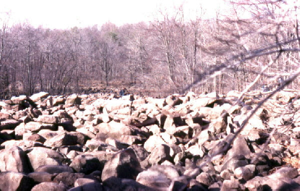
The photograph above shows Devil's Potato Patch, which is on the east side of the highway, as seen from the parking area, which is on the west side of the highway. Note the light-colored boulders. Note also the similar boulders on the slope above the "Patch," which is also evident on the aerial photograph in the previous image.

A closer view of the boulders within "Devil's Potato Patch" reveals they are identical in composition and are composed of the bedrock at this location -- the resistant Tuscarora Sandstone (the "Tuscarora Quartzite"). Large boulders stand high and small boulders are relegated to the depressions, similar to the way a large pebble will rise to the surface if a container of mixed-grain-sized sand is shaken. This is a periglacial deposit associated with the severe climate that existed a mere 17,000 years ago, during the last stages of the Pleistocene when the ice from the continental glacier that covered much of the US and most of Canada extended to within a few miles from here. THE GLACIER DID NOT REACH THIS SITE. IT DID NOT DEPOSIT THESE ROCKS. The extreme climate associated with the close proximity to the glacial margin shattered the bedrock Tuscarora Quartzite by the freeze/thaw process and these quartzite fragments were actively creeping down slope under these conditions. Because the ice has disappeared and the climate has moderated, the deposit is no longer creeping down slope. This, in effect, is a paleo-slope. which records the effects of a paleo-climate.

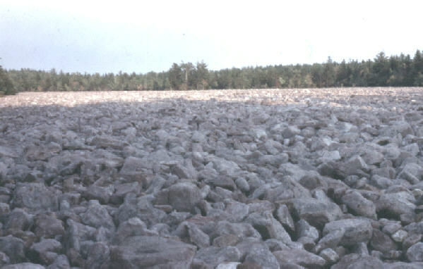
The photograph above shows a closer view of the boulders. The smaller boulders, which are found in the low areas of the deposit, still preserve their smooth surfaces caused by their mutual abrasion resulting from the freeze/thaw movement of the deposit. The thickness of the deposit of boulders is probably measured in tens, rather than hundreds, of feet. The deposit extends beneath the forest and veneers the entire mountain slope. The forest will "soon" ( a few hundred to a few thousand years) cover the entire deposit. The deposit of boulders has nothing to do with devils or with potatoes.
(Source: DeLorme 3-D TopoQuads)
The quickest way back to the Moravian campus is via PA Route 946 to Berlinsville and then PA Route 248 to PA Route 897, and following that route to Bethlehem.
Related Regional Geological Features that are NOT seen on these Field Trips
The largest and probably best know local boulder field is the Hickory Run Boulder Field in Hickory Run State Park, which is located near White Haven. The origin of this field is identical to that of "Devil's Potato Patch." Both were formed by the severe climate near the ice margin and both were creeping down a slight gradient during the severe climatic episode. Neither was deposited directly by the ice. They differ only in location, extent, and type of rock.
At Hawk Mountain, near PA Route 22 at Hamburg, there is a boulder field composed of blocks of the Tuscarora Quartzite from the summit of the nearby Blue Mountain. These boulders crept down the mountain front under severe climatic conditions of the glacial period into the lowest spot -- the channel of a small, pre-existing stream. The small stream still flows beneath the boulders in its channel. The forest subsequently grew up to cover the slope of the mountain except where the boulders were the thickest. A small flow of water can be heard trickling beneath these large boulders. Like "Devil's Potato Patch," this is a periglacial deposit. The ice from the glacier never extended this far south.
Ringing Rocks Boulder Field is located near the Delaware River, on the Pennsylvania side, in the vicinity of Ralph Stover State Park. The boulders here are made of diabase, which is the dark intrusive igneous rock (diorite-to-gabbro) that was seen on stops 3 and 4 of field trip #1. The diabase formed from a basaltic magma that cooled slowly beneath the Earth's surface during Triassic time, and consequently has an intermediate grain size and a uniform composition. This rock has a "salt-and-pepper" homogeneous interior composed of lighter feldspars and darker pyroxenes. Weathering subsequent to the Triassic Period eroded the land surface to expose these rocks to the action of the atmosphere. Freeze and thaw broke the exposed rock into large blocks. The feldspars on the surface of the exposed blocks were converted by chemical weathering to clay. The clay is less dense than the parent feldspars, so it expands in the weathering process. This expansion of the weathered block surface puts the unweathered interior of the block under tension. This tension is a stress that changes the physical properties of the rock so that some of the blocks within the boulder field will "ring" when struck by a hammer. Hence the name, "Ringing Rocks." Like the others, this boulder field was NOT deposited directly by the ice; rather, it is periglacial deposit formed from the underlying bedrock. This deposit was creeping down slope under the severe climate that existed at this location during the time of the last glaciation, but under the moderate climate that now exists, the deposit is no longer moving. It will, however, be remobilized during the next glacial cycle.
End Stop #5 of Field Trip #2
(all photographs by J. Gerencher)