Lehigh Valley Geology Field Trips
Field Trip 1, Stop 2
Hardyston Quartzite: A Distinctive and Useful Rock
(Click on images to enlarge)
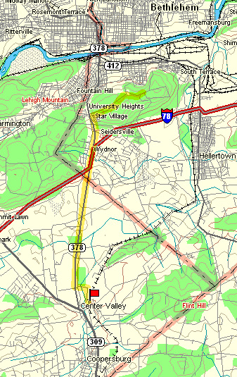
(Source: DeLorme 3-D TopoQuads)
Follow PA Route 378 south to Landis Mill Road east. Stop where the Landis Mill Road crosses the abandoned railroad track, which is at the base of a small hill about 200 meters north of the campus of DeSales University. The railroad bed has been converted to a rails-to-trails path suitable for walking and bicycling by Upper Saucon Township. Walk northeast on the former railroad bed about 20 meters. The outcrop is along the left side of the rails-to-trails path.
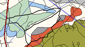
(Source: ArcView GIS Software)
The geologic map above portrays situation along the former railroad track. On the map, the Hardyston Quartzite is colored gray, the gneiss as rust-colored, and the younger limestones/dolomites of the valley floor are portrayed as whites and blues. The limestones/dolomites make a flat and low valley floor, whereas the Precambrian gneiss makes a hill wherever it occurs. This stop, in the Hardyston Quartzite, is at the base of the hill and the hill is composed of the Precambrian gneiss. It is important to note here that the Hardyston Quartzite is located between the Precambrian gneiss and the limestone/dolomite of the valley floor. The Hardyston Quartzite is younger than the gneiss and older than the limestone/dolomite, so you would expect to find it between them, as is the situation at this location.
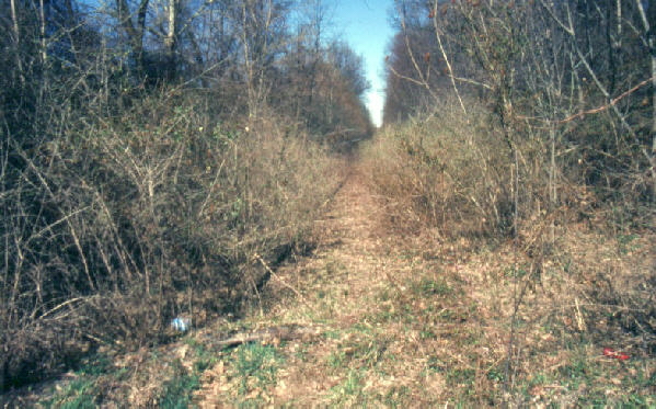
When this picture was taken, the railroad tracks had been abandoned and overgrown, but Upper Saucon Township has recently converted the former railroad bed into a easy walking/bicycling path. The exposure of Hardyston Quartzite is located behind the bushes on the left in the photograph.
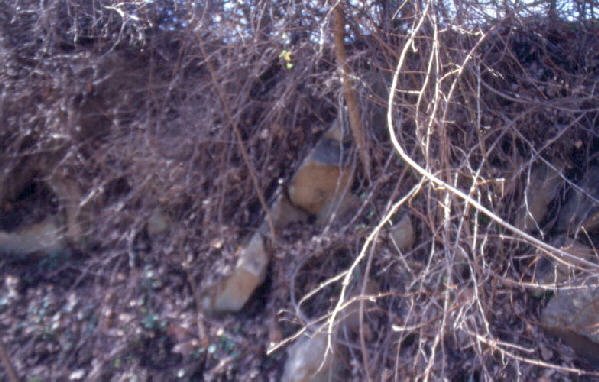
The Photograph above shows the Hardyston quartzite beds, that are exposed here, dipping to the left. Note the iron staining. These beds were deposited as a beach sand along the edge of an ancient ocean. The beach sand was deposited on top of the eroded-off surface of the Precambrian gneiss (seen at Stop #1A). Subsequent deformation during the building of the Appalachian Mountains metamorphosed these quartz sands to the very resistant quartz rock, called a quartzite, and tilted the beds from their original horizontal position. The Hardyston Quartzite is a relatively thin formation with a total thickness which varies from 600 feet near Reading to only 60 feet near the Delaware River. This distinctive quartz-rich metamorphic rock separates the older gneisses beneath from the younger and much thicker limestone/dolomite formations above.

The oxidation of iron within the Hardyston Quartzite produces the distinctive surface coloration which makes it an attractive building stone. Note that the coloration of the iron oxidation extends into the rock about a half-inch depth. The interior of the sample appears a uniform gray because the iron within the interior is chemically unoxidized.
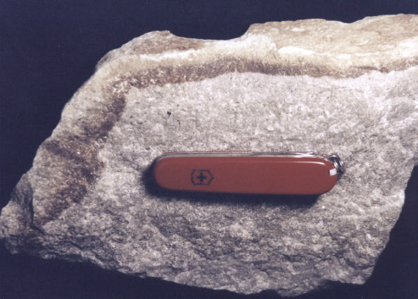
The picture above shows the oxidation of the iron extending about a half-inch into the sample of Hardyston Quartzite. The quartz sand grains of the original sandstone were annealed into a quartzite by the heating and compression associated with the metamorphism. The metamorphism, in turn, resulted from the forces that produced the Appalachian Mountains.

The picture above shows Colonial Hall, on Moravian's main campus, which is faced with the Hardyston Quartzite. Note the color of the stone on the face of the building is the same as the surface of the sample in the previous photograph.. Note also the iron staining washing down the left edge of the building from the one block of stone that is about the level of the second floor window sill. In time the building will weather to progressively darker colors, and ultimately to black, similar to this block and those beneath it.
(Moravian College file photo)
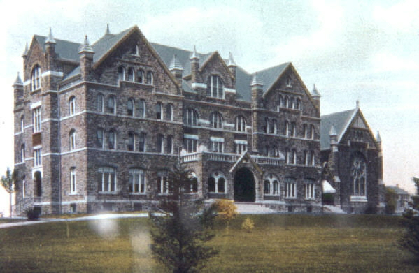
The photograph above shows Comenius Hall as it appeared shortly after it was built in 1892 on the Moravian College main campus, but before an additional wing was added to the left end of the building in 1907. The entire building is faced with the Potsdam Quartzite, which is the name given to the rock formation equivalent to the Hardyston Quartzite in New York state. Notice on the photograph above (a hand-colored black-and-white picture, as was done at the time) that the rock facing of the building is relatively light in color.
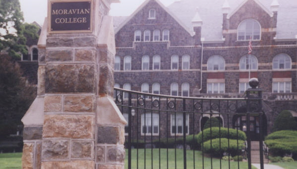
Notice how the rock facing of Comenius Hall weathered to progressively darker colors and, ultimately, to black over about a century. Air pollution from heavy industry in the Lehigh Valley during the earlier part of this period probably exacerbated the rate and extent of the weathering. The pillar in front of Comenius Hall in the photograph above is made of the Hardyston Quartzite. The pillar was installed in the 1990's and was disassembled, cleaned, and reassembled in 2003. Over time, it will progressively darken to ultimately match the color of Comenius Hall in the distance.

(Source: ArcView GIS Software)
The above map shows the distribution of the Hardyston Quartzite in Lehigh and Northampton counties as the color gray; all other rocks are indicated as white. Notice that, because the formation is relatively thin, the surface expressions of this formation are long and thin. On most map positions, it separates older Precambrian rocks from formations of Cambrian-age or younger.
Related regional geological features NOT seen on these field trips.
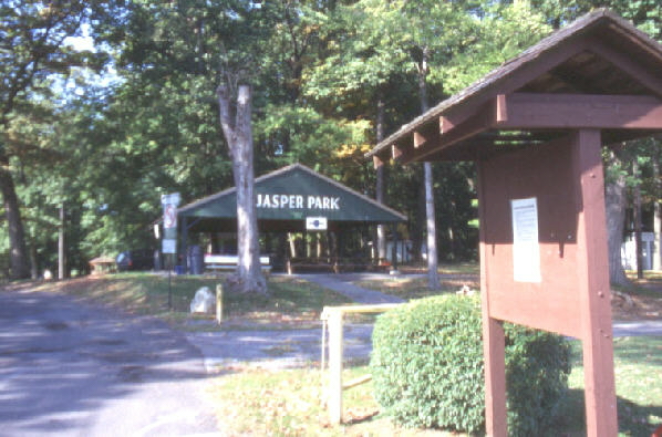
The Hardyston Quartzite is the source rock for the jasper that can be seen at Jasper Park in Vera Cruz, which is several miles south of Allentown. Native Americans used the jasper, which is a form of flint (cryptocrystalline quartz) with iron oxide, from this location for making arrow heads and other stone implements. In the park you can see pits in the ground with shards of jasper which resulted from the human working of these deposits for hundreds, perhaps thousands, of years. THERE IS NO SPECIMEN COLLECTING ALLOWED WITHIN THE PARK BOUNDARY.
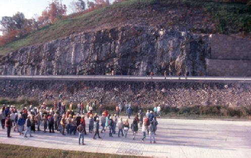
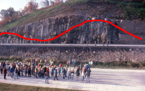
Along Interstate 78, near the NJ / PA border, the Hardyston Quartzite is exposed over the Precambrian gneiss. The second photograph highlights the separation of the units, which here is a fault contact. The geologists in the picture are studying this exposure during the construction phase of I-78, so they could walk on the road surface without worrying about traffic. ONLY EMERGENCY PARKING IS PERMITTED ALONG INTERSTATE HIGHWAYS. DO NOT PARK AT THIS LOCATION.
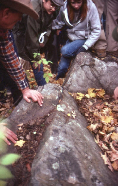
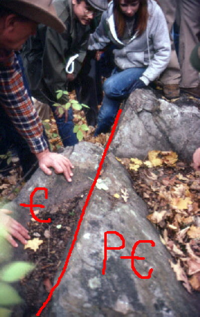
The Hardyston Quartzite / gneiss contact is exposed in Franklin County, NJ. The Hardyston Quartzite is Cambrian in age and the gneiss is Precambrian in age. The gneiss dates at about one billion (1000 million) years, whereas the Hardyston Quartzite is about than half that age, so there is at least 500 million years missing between these two rock units. This is called an unconformity and it represents the hiatus (break in time) during which the older rock was being eroded before the sediments, that would become the younger rock, were deposited on top of the erosional surface.
End Stop #2 of Field Trip #1
(all photographs by J. Gerencher, except for the Moravian College file photo)